Thermal infrared sensor, 12 m
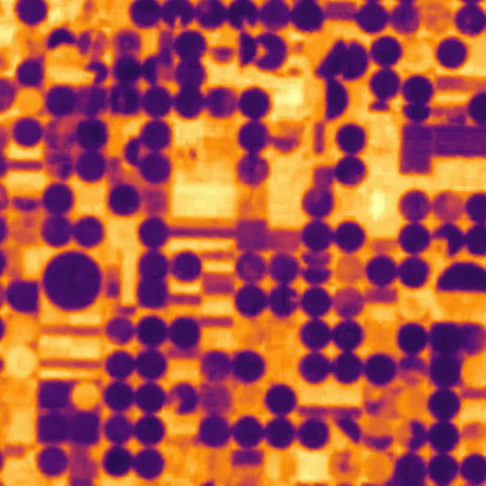
Surface temperature by day or night. Irrigated fields stay cool, dry ground and roofs run hot, and an industrial leak or a fire shows up before the smoke does.
Specification
PH-T payload on the Perihel standard bus, orbit 525 km sun-synchronous.
| Ground sample distance | 12 m (long-wave infrared, resampled from 11 m) |
|---|---|
| Swath width | 22 km |
| Spectral bands | Two long-wave bands: 10.3 to 11.3 µm and 11.5 to 12.5 µm |
| Radiometric resolution | 14 bit |
| Absolute accuracy | ±1.5 K (blackbody-referenced, once per orbit) |
| Sensitivity (NEdT) | 0.1 K at 300 K |
| Revisit, one satellite | 4 days, day and night |
| Local overpass times | 10:30 and 22:30 |
| Pointing | Up to ±25° off nadir |
| Calibration | On-board blackbody and deep-space view each orbit |
| Downlink | X-band, 800 Mbit/s |
Products and formats
Every scene is delivered as a cloud-optimised GeoTIFF with a STAC item. Levels are cumulative: you can order L1B and reprocess to L2 later.
| Level | Content | Format | Delivery after downlink |
|---|---|---|---|
| L1B | Calibrated at-sensor radiance, sensor geometry | COG GeoTIFF, float32 | 30 min |
| L2 | Land surface temperature in kelvin, emissivity corrected | COG GeoTIFF, int16, scale 0.01 | 50 min |
| L2 anomaly | Thermal anomaly mask against 30-day local baseline | COG GeoTIFF + GeoJSON polygons | 50 min |
| L3 | Monthly day and night temperature composites | COG GeoTIFF | Within 24 h |
Example products
Resolution and revisit
Revisit of a mid-latitude point improves with every satellite you add to the plane. See the coverage page for the ground tracks.
| Satellites | Revisit |
|---|---|
| 1 | 96 h |
| 3 | 32 h |
| 6 | 16 h |
| 12 | 8 h |
Typical uses
- Irrigation and water stress
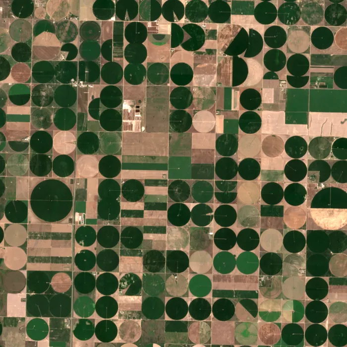
- Irrigated pivots read about 17 °C cooler than dry ground in the example frame; a failing pivot warms within days.
- Urban heat
- Surface temperature per block for heat action plans and cooling investment.
- Industrial monitoring
- Flares, cooling towers, stockpile fires and process heat at plants and mines.
- Wildfire and burn scars
- Active fire detection on every pass, day and night, plus burn severity afterwards.
Sample delivery
Each scene arrives with a STAC item that any STAC client reads. Query it through our API or find it next to the data in your own bucket.
Delivered item, abbreviated
{
  "type": "Feature",
  "stac_version": "1.0.0",
  "id": "PH-THE-20250728-173012-0412",
  "collection": "perihel-thermal-l2",
  "properties": {
"datetime": "2025-07-28T17:41:08Z",
    "perihel:level": "L2",
    "gsd": 12,
    "perihel:lst_scale": 0.01,
    "perihel:lst_unit": "K",
    "eo:cloud_cover": 0.4,
    "proj:epsg": 32614
  },
  "assets": {
    "data": { "href": "s3://your-bucket/perihel/perihel-thermal-l2/PH-THE-20250728-173012-0412.tif",
              "type": "image/tiff; application=geotiff; profile=cloud-optimized" },
    "metadata": { "href": "s3://your-bucket/perihel/perihel-thermal-l2/PH-THE-20250728-173012-0412.json" }
  }
}
Questions about thermal
The detector samples at 11 m and the product is resampled to 12 m on a common grid with the optical payload. The sharp edge of a field is visible; the temperature of a single car is not.
At 22:30 the ground has lost its solar heating, so industrial heat, urban heat islands and leaks stand out more clearly than by day.
Yes. Many customers task an optical and a thermal satellite over the same area; both are delivered on the same grid.
Task a thermal satellite
Tell us the area and the revisit you need. An engineer replies with orbit, sensor and fee.